

Tartaria Wasn’t the Only Empire ERASED
Exposing Another Country They Wiped From the Map

Aside from Tartary, dear reader, you may be forgiven for thinking there are few other examples of historical names quietly slipping from memory; yet the deeper one walks into old books and maps, the more often these forgotten places begin to appear.
One name, in particular, has followed me for some time now:
Barbary
From the earliest days of my searching, some two years past, right up to the present hour, I have found this name again and again, printed plainly in works that were never written for mystery, speculation, or romance, but for education, navigation, geography, and public knowledge.
It appears not as some vague whisper from the margins, but as a known and commonly referenced part of the world.
And yet, if one turns to the modern record, Barbary is generally explained away as a loose term; a broad region of North Africa, never truly a country, never a single defined empire, and certainly not something to be spoken of in the same breath as those old geographical works so often suggest.
But here, dear reader, is where the matter becomes interesting.
For when we turn away from the modern summary and open the older records for ourselves, we find language that does not always sit comfortably beside that explanation.
We find historic geographical dictionaries repeatedly naming Barbary as a country; a clear, defined geopolitical reality, not some vague or unrefined stretch of land.
That is the simple truth written in these old pages.
I am not asking you to accept this claim blindly, dear reader; I ask only that we let the old records speak for themselves, exactly as they were set down.
Because if modern history insists Barbary was never a country, while those same historic sources describe it as one without hesitation, then we are not dealing with a minor difference of opinion.
We are looking at two accounts that stand in direct, unmistakeable opposition.
One reduces the name to a loose, empty label; the other presents it as a distinct, established land, known, documented, and recognised as a country in its own right.
And that, curious mind, is precisely where our work begins.
So let us bring this preamble to an end and turn to the records themselves.
Let us look closely and patiently, letting the evidence speak fully before any conclusions are drawn.
Then you may decide for yourself, dear reader:
What is Barbary?
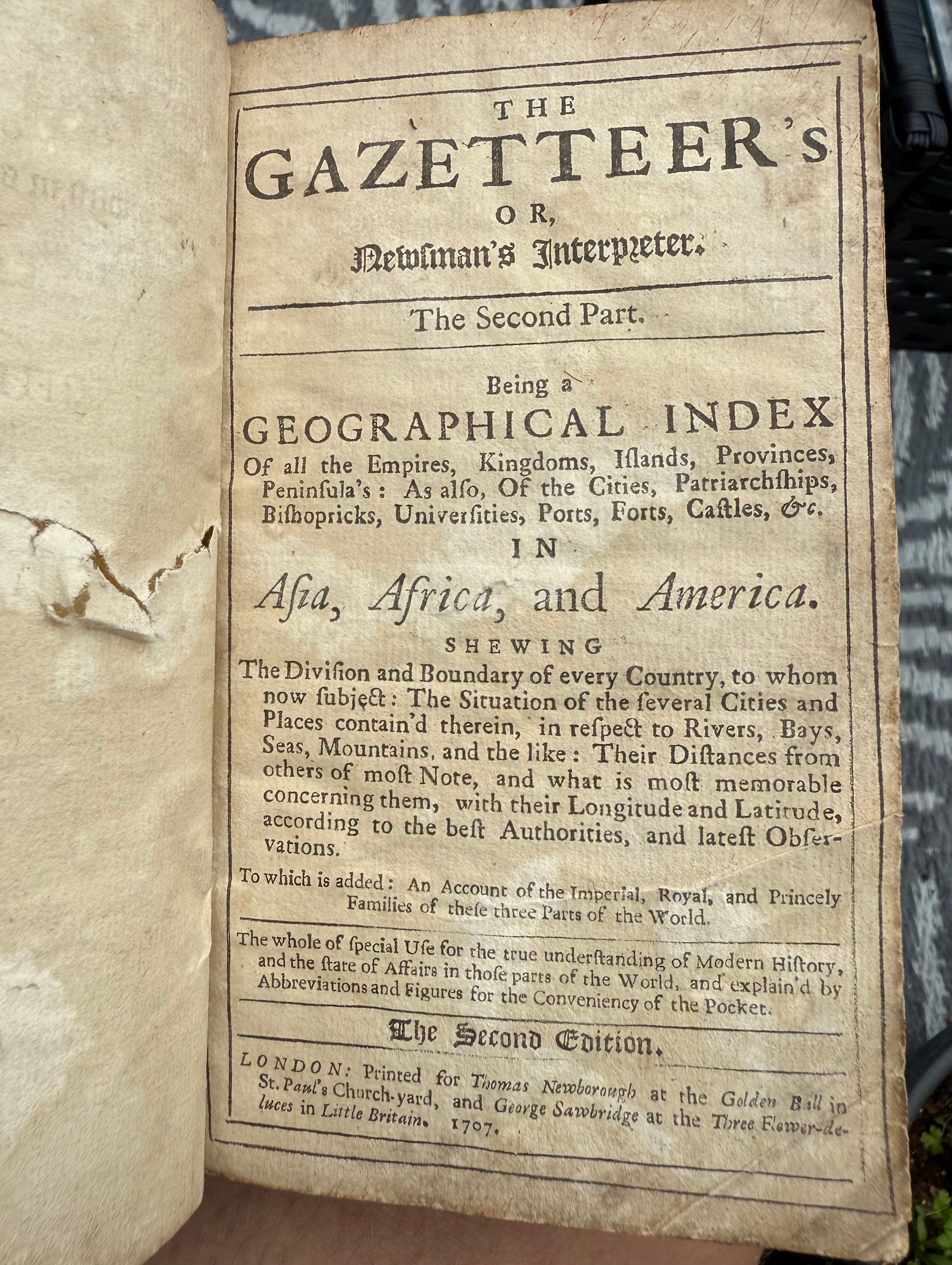
We begin our inquiry, dear reader, with a reference from a book printed in London in 1707:
The Gazetteer’s, or, Newsman’s Interpreter
This is no speculative tract, and no work of fancy or agenda.
Its purpose is plain upon its title page:
to serve as a geographical index of all empires, kingdoms, provinces, cities, and ports across Asia, Africa, and America
setting forth their boundaries, situation, rulers, and principal features, according to the best authorities and latest observations
It was compiled for practical use; for merchants, travellers, scholars, and any who sought a reliable account of the world as it was then understood.
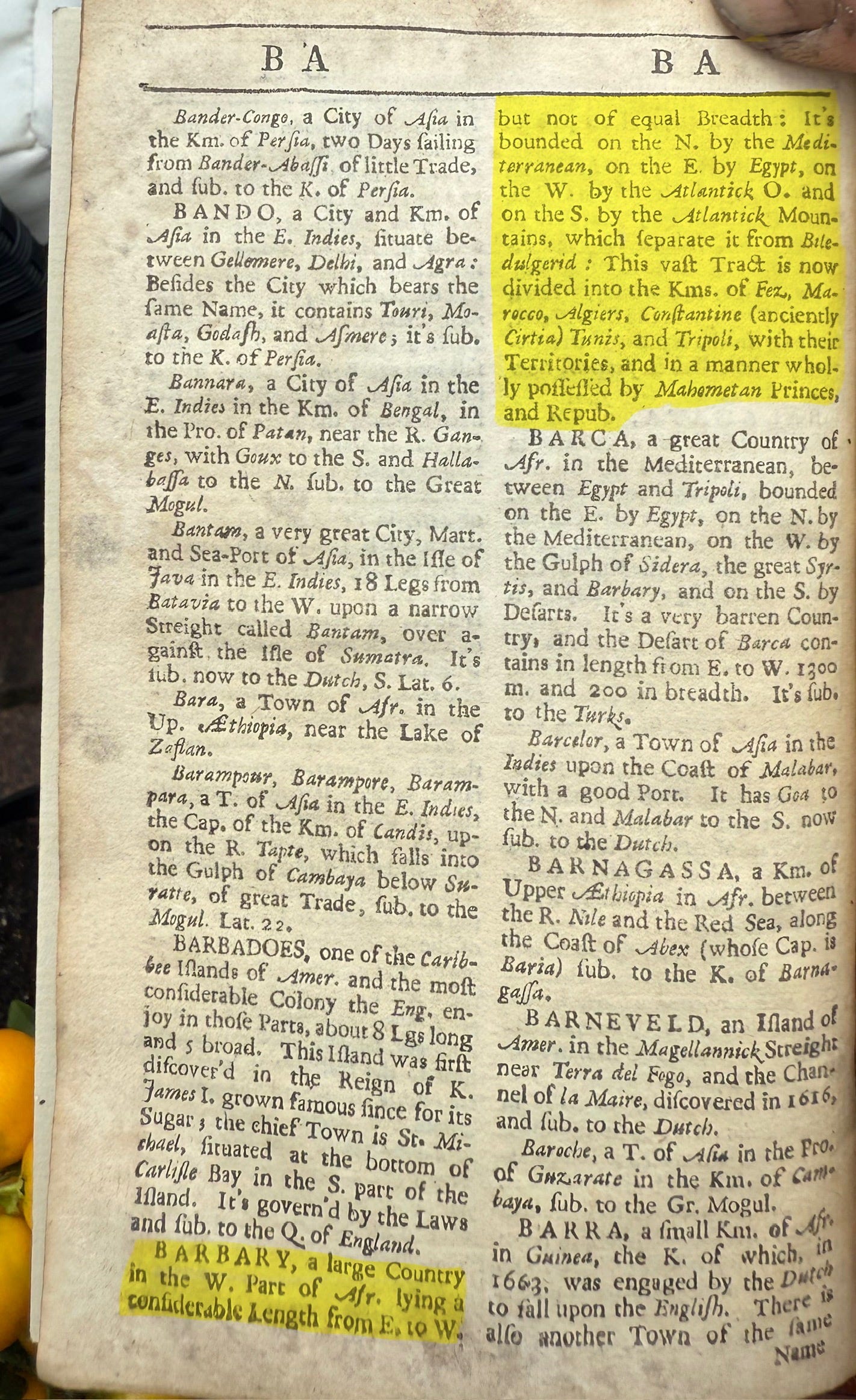
When we turn to its entry for Barbary, the words stand unmistakeable, printed clearly for all to read:
“BARBARY, a large Country in the W. Part of Afr. lying a considerable Length from E. to W. but not of equal Breadth: It’s bounded on the N. by the Mediterranean, on the E. by Egypt, on the W. by the Atlantick O. and on the S. by the Atlantick Mountains, which separate it from Biledulgerid: This vast Tract is now divided into the Kms. of Fez, Morocco, Algiers, Constantine (anciently Circia) Tunis, and Tripoli, with their Territories, and in a manner wholly possessed by Mahometan Princes, and Repub.”
There is no hesitation here, dear reader, no vague phrasing, and no reduction to a mere region.
It names Barbary explicitly as a large country; defines its exact location, its full extent from east to west, its clear borders by sea and mountain, and enumerates the kingdoms and rulers within it.
It describes it as a coherent, bounded, and geopolitically recognised land; exactly the status modern history insists it never held.
The contrast could not be sharper.
Today we are told Barbary was never a country, never a defined entity, only a loose term for a stretch of coast.
Yet here, in a trusted reference work written three centuries ago, intended to record facts for the public record, it is presented without qualification as a large country; with fixed boundaries, internal divisions, and established governance.
It is not a matter of shifting definitions or changing language.
It is simply this:
what was once entered plainly as a country in a standard geographical dictionary has since been erased from that status and reduced to a vague label
The gazetteer does not interpret, it documents.
And what it documents stands in direct contradiction to the story we are taught.
I ask you again, curious mind:
If Barbary was never truly a country, why did those who lived closer to its time and geography describe it as one with such precision and certainty?
This is not conjecture, it is evidence, laid bare in black and white for us to weigh.
And as we shall see, this is far from an isolated case.
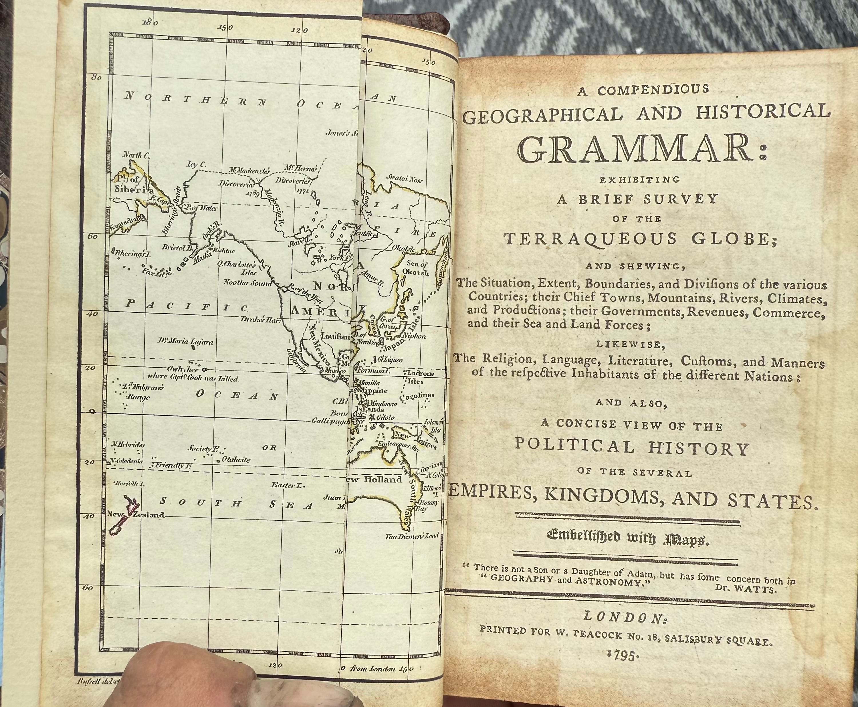
If the gazetteer from 1707 stood as a clear witness, dear reader, this next volume serves as its firm corroboration; printed in London nearly ninety years later, in 1795, titled:
A Compendious Geographical and Historical Grammar
It is a work of a different design:
a concise, systematic survey of the entire globe, crafted to lay out the situation, boundaries, dimensions, governments, and chief cities of every nation in ordered, tabular form
A text and reference book meant to instruct and inform without bias or fancy.
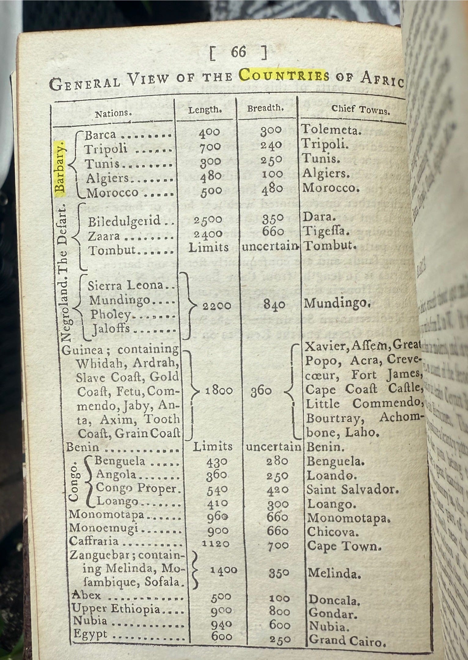
Turning to its General View of the Countries of Africa, we are presented not with prose, but with a precise, organised table; a layout that leaves no room for ambiguity.
There, at the very head of the list, Barbary is set apart as a distinct nation, clearly bracketed as one coherent whole, containing within it the kingdoms of Barca, Tripoli, Tunis, Algiers, and Morocco.
For each, the table gives exact measurements:
length, breadth, and principal towns, treating Barbary exactly as it treats Egypt, Congo, or any other fully recognised country on the page
You have seen the chart for yourself, dear reader; the facts are laid out in black and white, neat and unmistakeable.
It does not relegate Barbary to a vague region or a loose collection of tribes.
It assigns it a fixed place among the nations of the earth, with defined extent and internal divisions, just as consistently in 1795 as it was in 1707.
Here, then, is the pattern that modern history would have us ignore.
Two separate works, nearly a century apart, compiled for different purposes yet equally authoritative in their time; both name Barbary explicitly as a country, both define its borders and measure its size, both list its constituent parts with precision.
Yet today, we are told it never truly existed as such.
This is no small discrepancy; it is a complete reversal of what was once accepted fact.
Translation:
“1. So hot in the latter part of August that it melted chocolate and rosin; and julep taken later brought dryness and grossly swollen glands; and neither oil of jasmine nor rosewater, nor the sun, nor any other thing could endure it, nor even stay in the air for long.
About four in the afternoon, when there had been a bright gale of wind for two days before
2. They call each other “Companion”; some with blood of royal descent, some with that of the fox, and some with that of the hare; their eyes are very piercing.
3. Long in the valley parts, the air is much thicker there; their life is shorter, perhaps caused by the sharp, biting juice of the date, which makes up the greatest part of their food; and they live shorter lives in the valleys where the air is gross and very suffocating in hot weather.
4. And after this manner it is known throughout all Barbary.
5. Not known there at all.
6. Among them, they esteem a universal medicine for man and beast; for it purges the body just as our farriers do for horses to expel sickness.
They have certain poisons that kill, but not by administering them internally. Grains of Paradise are not known in Morocco.
7. Hashish is the tops of the wild hemp plant, mixed with honey into an electuary; but no more than half an ounce is to be taken at any one time.
8. They have no perfumes, except musk and civet, and that very rarely.
9. Rain falls most commonly in December and January; there are often very great winds and thunder. Sometimes they have rain in October, which yields great plenty for the year; and sometimes they have no rain for three years together.
There is a constant fear of earthquakes and locusts, which come in such abundance that they devour all that grows.
The plague also comes frequently; many people die of it. Most of the summer is very suffocatingly hot, yet the winds are much better than the sun’s beams; they blow up the dust so that it covers the ground.
Their fountains often rise up out of the sea, and sometimes great numbers of shooting stars appear, far more than in Europe.
Whirlwinds only blow sometimes, and carry sand far into the country, as far as Morocco.
10. The great Atlas mountain, when it comes near Morocco, seems to incline rather to the west than to the north, and runs more north‑to‑south than any other point of the compass. Its top is continually covered with snow; for the most part, it appears above the clouds.
There are many springs, but which way it lies, or how cold the top of the hill is, they do not know.
11. The fruit is very large, full of juice, and of various colours; but for the most part, inclining to red, of an extraordinary depth, and far sweeter than any found in Italy.
Where it grows, the land is altogether rocky, barren, and without water. Indian wheat grows there, both white and red; and another sort of grain they call Tuft‑wheat, whose stalk is as thick as a man’s arm and grows higher than a man’s height.
(Signed) Chas. Howard”
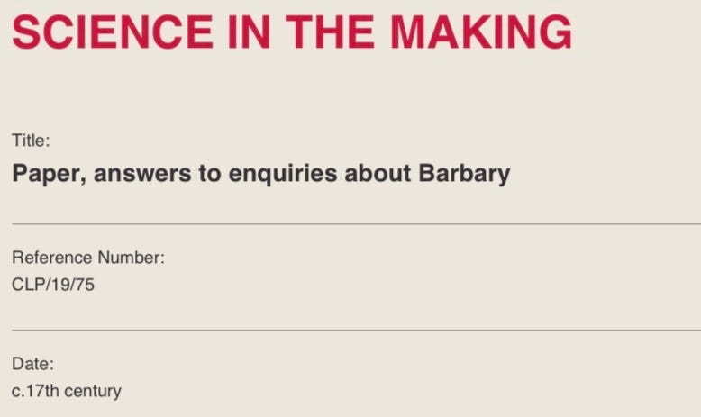
We come now to our final witness, dear reader, an original manuscript preserved in the archives of the Royal Society, catalogued as CLP/19/75 and dated to the latter half of the 17th century.
Unlike the printed works we have examined, this is no published volume for general instruction.
It is a working record:
Answers to Enquiries about Barbary
They are direct, unvarnished notes, set down in reply to formal questions put to those with firsthand knowledge of the land.
Though the original questions are lost, the answers remain, and they reveal far more detail about this mysterious country than any modern summary ever could.
What strikes immediately is the richness of these observations.
Barbary is never treated as a vague stretch of coast; far from it.
Its extremes of climate are vividly laid out; heat so fierce in late summer it melted chocolate and rosin; winds that brought relief yet also carried suffocating dust.
Years without rain followed by sudden, violent storms; and locust swarms vast enough to strip the land bare.
The customs and daily life are plainly described too, such as the modes of address, keenness of gaze, the simple diet that sustained the people, and remedies ranging from hemp mixed with honey to the absence of spices valued elsewhere.
Its natural wonders are recorded with wonder:
the great Atlas Mountain, its peak perpetually snow‑capped and rising above the clouds; springs that seemed to rise from the sea; shooting stars far more numerous than in Europe; and a remarkable grain whose stalk grew as thick as a man’s arm and taller than a man’s height
Even its medicines and poisons are set down precisely; what cured, what purged, what killed, and how.
This is not the account of a distant scholar; it is the voice of those who walked its soil, breathed its air, and observed its ways firsthand.
And throughout, the subject is never in doubt:
Barbary is referred to consistently as a distinct, coherent land; a country with its own character, bounds, climate, produce, and people
There is no hesitation, no hint it was anything less than a fully recognised geopolitical reality.
Once again, we are forced to ask:
How is it that such a detailed, intimate portrait of a nation, preserved in one of the world’s most respected scientific archives, has been reduced in modern history to nothing more than a loose, undefined region?
These answers do not just confirm what we have seen; they deepen the picture, filling it with life, colour, and undeniable substance.
And so, dear reader, a revealing lesson this evening, and one we shall now reflect upon.
What these pages lay bare is a Barbary that stands in stark, unmistakeable contrast to the faint, featureless outline we are offered today.
No vague stretch of coast, no loose label for scattered tribes, these records show a clearly defined, substantial country:
bounded, measured, inhabited, governed, and documented with the same care and certainty as any other recognised nation of its age
It had its own climate, its own produce, its own customs and remedies, its own mountains and cities, its own distinct identity.
Yet modern history has all but erased that reality, reducing it to little more than a footnote, as if it never truly existed as a coherent land at all.
And this, we know, is far from an isolated case.
We have walked this path before with Tartary; another vast, clearly documented realm once acknowledged across countless maps and volumes, now dismissed as nothing more than a myth or a misnomer.
The more one searches the archives, the more one turns the pages of old dictionaries, gazetteers, and manuscripts, the more such examples emerge:
lands once named, measured, and described in plain terms, now quietly struck from the record and explained away as misunderstandings or inventions
It brings a startling revelation:
our perception of history is not always a faithful reflection of what was, but a carefully curated version of it
Whole countries can be shrunk to labels, distinct nations blurred into regions, and solid, documented facts rewritten to fit a narrower, neater narrative.
It forces us to ask not just what we have been told, but what else may lie hidden beneath the surface; what other truths have been smoothed over, what other lands have been wiped from the map, and how much of our shared past has been shaped not by evidence, but by omission.
These discoveries do not just correct names or borders; they shift the very ground beneath our feet.
They remind us that the past is often far richer, far larger, and far more mysterious than the story we are permitted to read.
And they teach us that the surest path to truth lies not in accepting the summaries of today, but in turning directly to the records of yesterday; and letting them speak for themselves.
Before you move on, curious mind, a short word regarding support.
Please understand that nothing is required of you, and nothing is expected.
Your presence, your attention, and the fact that you walk alongside me in seeking out and preserving these truths; that is worth more to me than any sum of money ever could be.
Should you choose to give freely, out of nothing more than goodwill, know that every single contribution goes entirely toward one purpose:
tracking down, acquiring, and preserving rare, forgotten works exactly like this one, and gaining access to the archives where such evidence still lies
The books featured in this lesson were purchased with funds from your donations.
Thank you, dear reader.
Good job bro..In old maps North Africa was named BERBERIE , French for Barbary ,meaning lands of the Berbers aka Moroccans ...Today Algeria ,Tunisia ,Libya and part of Egypt were part of the Barbary Kingdom ,today known as Mooris Kingdom .America fought the Barbary Wars and Barabary Pirates are often cited and talked about in history books...I still maintain that TARTARY is nothing but BARBARY of the East ..Thanks bro ...continue your re-writing history work
I need to go back and catch up to this post. Love this stuff. Very interesting to me. Thank you for taking the time to share. Much love. 💖🙏👍